Support the Timberjay by making a donation.

New highway signs bring visibility to 1854 Treaty lands
REGIONAL- The recent installation of a dozen highway signs across the region marking the borders of the Treaty of 1854 between the U.S. government and three Anishinaabe tribal nations is the …
This item is available in full to subscribers.
Attention subscribers
To continue reading, you will need to either log in to your subscriber account, or purchase a new subscription.
If you are a current print subscriber, you can set up a free website account and connect your subscription to it by clicking here.
If you are a digital subscriber with an active, online-only subscription then you already have an account here. Just reset your password if you've not yet logged in to your account on this new site.
Otherwise, click here to view your options for subscribing.
Please log in to continue |
New highway signs bring visibility to 1854 Treaty lands
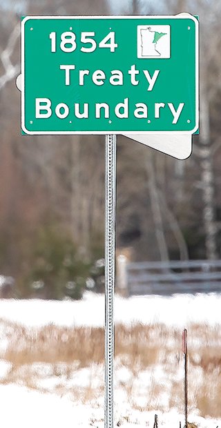
REGIONAL- The recent installation of a dozen highway signs across the region marking the borders of the Treaty of 1854 between the U.S. government and three Anishinaabe tribal nations is the culmination of an 11-year quest to raise visibility about tribal sovereignty rights in the ceded territory.
Tribal leaders from the Grand Portage Band of Lake Superior Chippewa, Bois Forte Band of Chippewa, and Fond du Lac Band of Lake Superior Chippewa joined Minnesota Department of Transportation officials for the installation of the first sign on Nov. 1, on southbound Highway 61 just south of the Canadian border near the entrance to Grand Portage State Park.
“It is something that was long overdue,” Grand Portage Band Chairman Robert Deschampe said. “When people enter the 1854 Treaty area they will know where they are and, hopefully, educate themselves about treaties.”
Deschampe first asked for signs recognizing the treaty boundaries 11 years ago, said Levi Brown, director of tribal affairs for MnDOT. The Bois Forte and Fond du Lac Bands followed with their own formal requests.
Brown, who’s a member of the Leech Lake Band of Ojibwe, acknowledged it’s been a long journey to get to this point. He said it’s important for the state to recognize and honor tribal sovereignty and rights of the Anishinaabe tribal nations in the ceded territory.
“We’re acknowledging the fact that as the state of Minnesota, we see the tribal nations, we see the treaties and are honoring those treaties. And that is a huge step,” he said.
The Minnesota Department of Transportation has installed the first of 12 signs to permanently mark the boundaries of the 1854 Treaty between the United States and three Anishinaabe Tribal Nations. The treaty transferred ownership of nearly five-and-a-half million acres across Minnesota’s Arrowhead region to the government in exchange for ongoing tribal hunting, fishing, and gathering rights, as well as land for reservations and annual payments of cash, goods, agricultural supplies and school funds of less than $20,000. Today, the 1854 Treaty Authority manages and protects the area’s natural resources and tribal rights on behalf of the Bois Forte and Grand Portage Bands.
MnDOT Public Affairs Coordinator Margie Nelson said Tuesday that all 12 signs have now been installed. One is near the intersection of Highway 53 and Highway 1 just north of Cook, where the treaty boundary line crosses. Others in the area include one on Highway 169 near Chisholm and one on Highway 37 near the Hibbing airport.
MnDOT worked with the Advocacy Council for Tribal Transportation, which is made up of 11 Tribal officials representing Tribal nations in Minnesota, to acknowledge land ceded by Tribal governments through treaties.
MinnPost contributed to this article.


