Support the Timberjay by making a donation.

Flooding hits record levels
Crane, Kabetogama water levels blow past 2014 mark
REGIONAL- The mounting crisis for regional lakeshore property owners and resorts entered a record-breaking phase late last week when water levels at Crane Lake and Lake Kabetogama blew past the …
This item is available in full to subscribers.
Attention subscribers
To continue reading, you will need to either log in to your subscriber account, or purchase a new subscription.
If you are a current print subscriber, you can set up a free website account and connect your subscription to it by clicking here.
If you are a digital subscriber with an active, online-only subscription then you already have an account here. Just reset your password if you've not yet logged in to your account on this new site.
Otherwise, click here to view your options for subscribing.
Please log in to continue |
Flooding hits record levels
Crane, Kabetogama water levels blow past 2014 mark


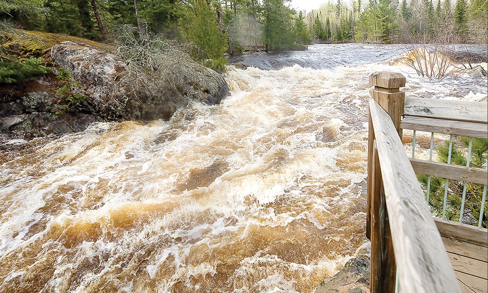

REGIONAL- The mounting crisis for regional lakeshore property owners and resorts entered a record-breaking phase late last week when water levels at Crane Lake and Lake Kabetogama blew past the damaging highs of 2014, with another foot or more expected before the surge levels off.
As of Wednesday morning at 3 a.m., the monitoring station at Crane Lake recorded the lake level at 1,121.94 feet, up over two-and-a-half feet since May 4, and nearly a foot higher than the 2014 mark of 1,121.
The Gold Portage outlet meter at Kabetogama hit 1,121.34 on Wednesday morning, almost three-and-a-half feet higher than May 4, and almost three-quarters of a foot higher than 2014’s 1,120.65 level.
And in news no one wanted to hear, the water will keep on rising through Sunday at a rate up to four times more than projected on Sunday. On Tuesday, the National Weather Service had revised its forecast for Namakan Lake, calling for an increase of 12 to 16 inches between Monday and this Sunday, which will also impact Crane and Kabetogama.
The major threat last week was damage to boat docks that were almost all submerged by the weekend, with those not underwater mostly inaccessible. But as the new week dawned ,numerous resorts and homes were facing serious challenges.
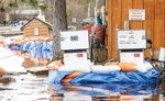
“Sandy Point and Northern Lights resorts are in the worst shape as far as trying to keep the water out, and Arrowhead Lodge, that’s coming up,” said Kabetogama Township Clerk Mary Manninen on Tuesday. “At Sandy Point they get it to where they think they’re good, and the water comes up. Now they’re working hard to keep adding sandbags. It’s just crazy the amount of sandbags we’re putting out here.”
A private residence on Sandy Point that was surrounded by sandbags on Saturday became an island over the weekend, and volunteers were hard at work there, too, Manninen said.
Crane Lake resident and business owner Mark Anderson shared what he knew of the situation there Tuesday afternoon at the local sandbagging site.
“It’s real challenging, and it’s a shame,” Anderson said. “Norway Lodge had to shut half their resort down and shut their motel down. All that they have left open is their RV park. Scott’s Resort is having a heck of a time. You’ve got to walk around water just to get into the restaurant and bar, but they’re trying to make that work over there. Resorts are taking bags, private homes are taking bags. There’s a lot of cabin owners that aren’t here, and when they get up here for the weekend they’re going to be grabbing bags. There’s so much in jeopardy – waves are coming right off the lake and hitting these buildings. It’s challenging.”
The waters of Crane Lake were within a few feet of Gold Coast Rd. and had swamped the main entrance to Voyagaire Lodge on Tuesday, although the lodge was still accessible through a secondary entrance.
Meanwhile, volunteers in both communities have been distributing sandbags by the thousands.
Manninen said that volunteers in Kabetogama have churned out well -over 10,000 sandbags thus far, with the county having delivered 24 or 25 truckloads of sand to the town hall parking lot. The number of volunteers working at any one time has varied from around ten to two dozen, and this week they’ll have some additional helping hands.
“We’ve got a crew of eight from the Conservation Corps,” Manninen said. “They came up yesterday and they’re helping for the week.”
Crane Lake got help of a different sort from Beth Bak, who did some online research and created a bagging apparatus that can be filled with a front loader to make eight bags at a time.
“Yesterday, in three hours we did 1,000 bags. Today in six or seven hours we did 2,500 bags. That’s 3,500 bags in two days. That’s kicking them out. We’ve had a lot of good community support. Yeah. I mean, what the heck, we even had one of our local sheriff’s deputies here today.”
On the docks
The causes of the current water calamity and that in 2014 are quite different, but both have had a telling effect on damage to boat docks.
Heavy June storms in 2014 dumped over nine inches of rain in portions of the Rainy River Basin. With water levels already high, another storm packing winds of 50-60 miles per hour was all that was needed to wreck boat docks throughout the region, creating huge waves that crashed through docks not yet covered in water.
Pine Tree Cove Resort owner Phil Hart lost all of his docks in that storm, but like other resort owners at Kabetogama, he built back stronger and smarter.
“These are all new docks,” Hart said. “They all got knocked out in 2014 when it was close to hurricane-force winds. Almost everybody lost their docks and rebuilt. Now they’re underwater.”
That’s because this year’s flooding has been driven by record-breaking April rains and snow, including an April 22-23 drencher falling on lingering snowpack that resulted in about eight inches of water rushing into area lakes and streams. With most lakes still ice-covered at the time, the excessive runoff created pressures that turned the ice into frozen bulldozers that mangled or destroyed some docks and weakened others.
Frequent May rains have continued to add to the influx, and as the waters have risen, docks have been in danger of being dislodged and floating away. Dock owners have tried to counter by weighing down their docks with water-filled barrels, sandbags, and even water-filled boats, all to mixed success.
“Many resorts have piles four and five high of sandbags on their docks hoping to save them,” Hart said. “We’ve seen sections floating down in front of us, so there are some docks that are lost, and we’ve seen barrels floating by. It’s going to be a challenge that could go into July. We aren’t even to our rainiest months of June and July.”
Jeff Kreuger at Krueger’s Harmony Beach Resort in Kabetogama said they’ve taken an additional step to try to preserve their dock.
“We had a new dock built about four years ago, so it’s pretty structurally sound. But we took off about 250 of our deck boards to take away some of the water lift. Maybe it was overkill, but I’d rather be safe than sorry. And we have barrels on our slip docks. Every morning I wake up and take a look outside with my fingers crossed.”
It’s the eighth season for Jeff and his wife Sheri at Harmony Beach, having bought the property in 2015 after having looked at it in 2014.
“We actually looked at it when there was high water and we still bought it,” Jeff said. “We must be crazy, but you know what, we’ll make a go of it. This, too, shall pass.”
High water didn’t keep the anglers away on opening day this past weekend, and bookings in the weeks ahead are holding up well, both Krueger and Hart said. However, submerged docks aren’t ideal when it comes to pleasing resort customers.
“It’s just inconvenient when our cabins are full,” Hart said. “They just have to put their boat in and out every night.”
“None of the docks are accessible at any of the resorts,” Krueger said. “Everybody’s going to have to launch their boats, go out and fish, then load them up and come back.”
Inconvenient, as well, is all the flotsam dislodged by the rising waters that makes navigation on the lakes hazardous. Boaters on all the region’s lakes have to keep a sharp eye out for derelict dock sections, once standing trees that have toppled into the water, fallen timber floated off shorelines, and more.
More rain was in the forecast for the end of this week, and lake levels aren’t expected to recede significantly now until early June.
Recreational areas
With the late ice-out on the region’s lakes, Voyageurs National Park was already facing a compressed timeline to get ready for the summer season, and high water isn’t making that any easier, according to park superintendent Bob DeGross, who spoke with the Timberjay on Monday.
“We just attained ice-out Thursday and Friday of last week, so our crews are just starting to get out and assess what sites are more impacted by the high water,” DeGross said. “A lot of our dock structure is inundated, beaches are covered, but campsites are pretty much high and dry.”
Submerged docks are also affecting how the park’s employees have to go about their assessments.
“The docks are inundated. We have a fleet of 45 boats for the park that are used in a variety of different ways. We’ve been able to get less than half of that in the water because we don’t have the marina space we typically do. We’re prioritizing what boats we need to get into the water to do the services that we have to do right now.”
For the moment, that means the park’s tour boats are sitting high and dry, but DeGross said he hopes they’ll be able to start tours by June 15.
Tours to Kettle Falls and services provided there to boaters are going to be affected by current conditions, DeGross said.
“They’ll be operating as much as they can, but things will be impacted in terms of having fuel out there,” he said. “The water is getting pretty close to the electrical systems that are needed for the fuel system and other things, and we will be having to shut those things off here in the near future. Kettle Falls will be disrupted in a variety of different ways.”
Boaters will need to keep several things in mind as they get out onto the park’s lakes.
For starters, the park has implemented a “no-wake zone” on May 13 that requires boats to travel at idle speed when they are within 300 feet of any dock or structure. The rule is in effect until June 1, but could be extended if conditions warrant.
DeGross also encouraged visitors to go slow elsewhere in the park.
“People should be aware of their wake just traveling along the open lake when they’re close to the shoreline, because that’s going to increase erosion in areas that aren’t typically in contact with the water level,” he said. “Those soils are susceptible to really being affected, and also the vegetation. We know how easily trees fall over once the soil gets inundated, and those wakes will just exacerbate that.”
The placement of marker buoys in smaller channels and around rocks will also look different because of the high water.
“The main channel markers should be OK, but the other markers are not going to be set as they typically are,” he said. “In the past, maybe we would set a rock marker a little bit off the rock so that people know to avoid the area, but now because of the water depth we might have to set it right on top of the rock. People should navigate away from rock markers a little more than they normally would.”
DeGross also cautioned boaters to be mindful of debris.
Visitors should expect to be dealing with high water conditions at least until mid-June, DeGross said.
“Hopefully we don’t get too much more rain over the typical May average. I heard that May is supposed to be wetter than typical,” he said. “It’s going to take a while for this to crest and also start to subside completely and everything. There’s some predictions that will be seen, you know, greater than normal water levels, you know, into early to mid-June, if not later than that.”
The Superior National Forest has also issued an advisory for the Boundary Waters Canoe Area Wilderness. “We are experiencing high water levels and flooding, creating unpredictable and hazardous situations for boaters, drivers and even hikers. Many roads across the forest are washed out or flooded, as are campgrounds, trails, portages and other recreation areas. Rivers and streams are very cold and fast moving. Please exercise caution, be prepared and call ahead to the local District Ranger office for the latest conditions,” the advisory says.


