Support the Timberjay by making a donation.

Warmest March-October on record in border country
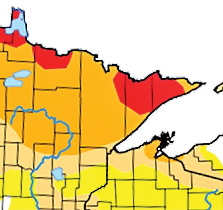
Last week’s rain fell only in western parts of the North Country; eastern areas remain in extreme drought
REGIONAL— This past October in the North Country was the warmest in more than a half a century, and part of a pattern of record-setting heat that set in on the region beginning last March. …
This item is available in full to subscribers.
Attention subscribers
To continue reading, you will need to either log in to your subscriber account, or purchase a new subscription.
If you are a current print subscriber, you can set up a free website account and connect your subscription to it by clicking here.
If you are a digital subscriber with an active, online-only subscription then you already have an account here. Just reset your password if you've not yet logged in to your account on this new site.
Otherwise, click here to view your options for subscribing.
Please log in to continue |
Warmest March-October on record in border country
Last week’s rain fell only in western parts of the North Country; eastern areas remain in extreme drought
REGIONAL— This past October in the North Country was the warmest in more than a half a century, and part of a pattern of record-setting heat that set in on the region beginning last March.
“February was the last time we had a month with below-normal temperatures,” said Kenny Blumenfeld with the state climatology office. “We’re really on a run of warm weather.”
While October wasn’t the warmest on record, it was the fifth warmest at International Falls, which has among the longest periods of record in the region. Summer-like temperatures in the first half of the month were tempered a bit by more seasonable weather in the final two weeks, notes Blumenfeld. Even so, the border city finished the month at an average temperature of 49.3 degrees, or 8.2 degrees above normal. “That’s a large anomaly,” noted Blumenfeld. International Falls also shattered its previous record for the latest freezing temperature, going all the way to Oct. 17 before the thermometer dipped below 32 degrees. That was nine days past the previous record, said Blumenfeld.
Yet the March-October span of weather in the North Country has been even more remarkable, notes Blumenfeld. The average temperature at the Falls during that eight-month stretch was 54.3 degrees, a full degree above the previous record for that same period. While March and April were mild, the heat really kicked in starting in May. “That’s when things really went off the charts,” said Blumenfeld. The summer heat wave fueled by a whopping 17 days above 90 degrees in the border city.
The summer likely would have been even hotter, notes Blumenfeld, but weeks of high-level smoke from wildfires across North America, helped moderate the daytime highs.
Does the mild stretch of weather, particularly in October, portend more of the same this winter? Blumenfeld said there’s typically little to no correlation between October weather and conditions that follow come winter. Last year was a good example, as a cold and snowy October was followed by an exceptionally mild winter, with relatively little snow.
Blumenfeld said November weather is generally a better predictor of the winter to come— and if that’s the case, there’s reason to expect another mild winter. While November started off seasonably, a substantial warm-up is forecast for the weekend, with temperatures running 8-10 degrees above average. The 6-10 day outlook shows a high probability of above-normal temperatures, a trend that continues into the 8-14 day outlook. Current extended forecasts call for little chance of any significant snow through the first half of the month.
Drought continues
While temperatures have run well above normal for months, precipitation continues to run well below normal, particularly east of Hwy. 53. While substantial rains in the western part of St. Louis, and much of Koochiching and Itasca counties, last week eased drought conditions there, those rains diminished sharply to the east. A portion of northeastern St. Louis County, around the Ely area, and most of Lake and Cook counties remain in extreme drought, according to the latest U.S. Drought Monitor map. “When it comes to precipitation, the consistent loser has been northern Lake County, bordering parts of St. Louis and most of Cook County,” said Blumenfeld.
The remainder of St. Louis County is still classified as in severe drought, but that could be modified when the latest drought map is posted Thursday morning.


