Support the Timberjay by making a donation.
North Country ripped by derecho
Fierce winds hit Ely and Lake Vermilion areas Friday
REGIONAL—A powerful storm early Friday, June 29, caused extensive tree damage and left thousands across the North Country without power, in some cases for days.
The National Weather Service has …
This item is available in full to subscribers.
Attention subscribers
To continue reading, you will need to either log in to your subscriber account, or purchase a new subscription.
If you are a current print subscriber, you can set up a free website account and connect your subscription to it by clicking here.
If you are a digital subscriber with an active, online-only subscription then you already have an account here. Just reset your password if you've not yet logged in to your account on this new site.
Otherwise, click here to view your options for subscribing.
Please log in to continue |
North Country ripped by derecho
Fierce winds hit Ely and Lake Vermilion areas Friday
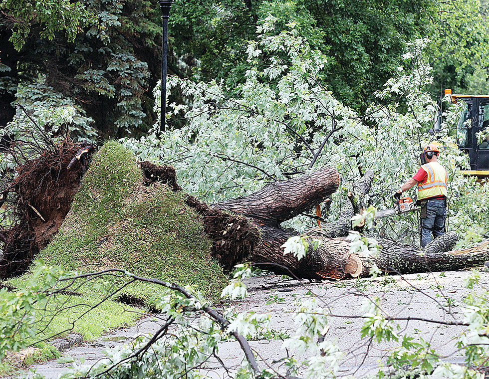
REGIONAL—A powerful storm early Friday, June 29, caused extensive tree damage and left thousands across the North Country without power, in some cases for days.
The National Weather Service has declared the storm a “derecho,” a term for a type of extremely strong storm capable of causing severe damage. “It was the same kind of storm system that came through on July 4, 1999,” said Carol Christenson, a meteorologist with the National Weather Service in Duluth.
Derechos can generate “downbursts of tremendous wind speeds,” said Christenson, which can cause the kind of tree damage experienced from Lake Vermilion to the Ely area on Friday. Christenson said a private weather station on Moose Lake, east of Ely, recorded an 80-mile-per-hour wind gust when the storm struck about 8 a.m. on Friday. Other reports around the area ranged from a 58-mph gust at Cook to 63 mph recorded by a ship just off Beaver Bay on Lake Superior. “Winds like that are going to take trees down, and might do some damage to outbuildings,” said Christenson.
Indeed, downed trees were common in the wake of the storm, although the worst damage was clustered in certain areas. Parts of Lake Vermilion, such as Birch Point and Isle of Pines, were hard hit, as was the Eagles Nest area and areas in and around Ely, Orr, and Babbitt.
In the immediate aftermath of the storm, more than 7,500 Lake Country Power customers reported they were without power. About 4,800 of those were restored by the following day, but customers remained without power over much of the weekend in some areas. According to Lake Country Power spokesperson Tami Zaun, the last of customers had their power restored by Monday evening.
Another major outage hit portions of Lake Vermilion and the Ely area on Monday, but it does not appear to have been storm-related and power was restored relatively quickly, said Zaun.
Within the city of Ely, city repair crews were kept busy on Saturday and Sunday as they worked to repair the damage. Power went out on Chapman Street and the western portion of the downtown district Friday about 7:30 a.m. and didn’t return until after 12:30 p.m. Trees were reported down on James Street and the southwest side of town and downed power lines affected the area near Amici’s Events Center on Central Avenue.
Residents along the Van Vac Road area on Burntside Lake, which had experienced severe damage last year and in 2016, were hit hard once again. Reports came in of trees down on a house on Moroni Point Road and another building sliced in half by a fallen tree. Some area resorts reported damage to facilities as well.
The severe weather was sparked by the influx of warm and humid air from the south, which often creates instability in the atmosphere, according to Christenson. She said such storms are unusual in June, since the upper air flow over the North Country tends to remain cooler until July. “Everything comes together when we finally get these strong south winds, bringing moisture and warm air up into the area,” she said.
The recent weather marks a noticeable departure from weather earlier in the month, which featured much more sunshine, lower humidity, and limited rainfall.
The change in weather has been caused by a shift in the jet stream just to the north of the region, which is allowing the warm and humid air mass over the central U.S. to finally make its way into the North Country.
The good news, said Christenson, is that the conditions are expected to change with the passage of a strong cold front later in the week. That is expected to drop high temperatures into the mid-70s, and substantially lower humidity levels.
“The weekend looks very, very nice,” she said.


