Support the Timberjay by making a donation.

Massive derecho wreaks havoc
Two deaths attributed to the storm, tens of thousands left without power
REGIONAL—Hurricane force winds pushed by one of the most powerful storms to hit northeastern Minnesota since the 1999 derecho, blasted through the region early Thursday morning, July 21, flattening …
This item is available in full to subscribers.
Attention subscribers
To continue reading, you will need to either log in to your subscriber account, or purchase a new subscription.
If you are a current print subscriber, you can set up a free website account and connect your subscription to it by clicking here.
If you are a digital subscriber with an active, online-only subscription then you already have an account here. Just reset your password if you've not yet logged in to your account on this new site.
Otherwise, click here to view your options for subscribing.
Please log in to continue |
Massive derecho wreaks havoc
Two deaths attributed to the storm, tens of thousands left without power
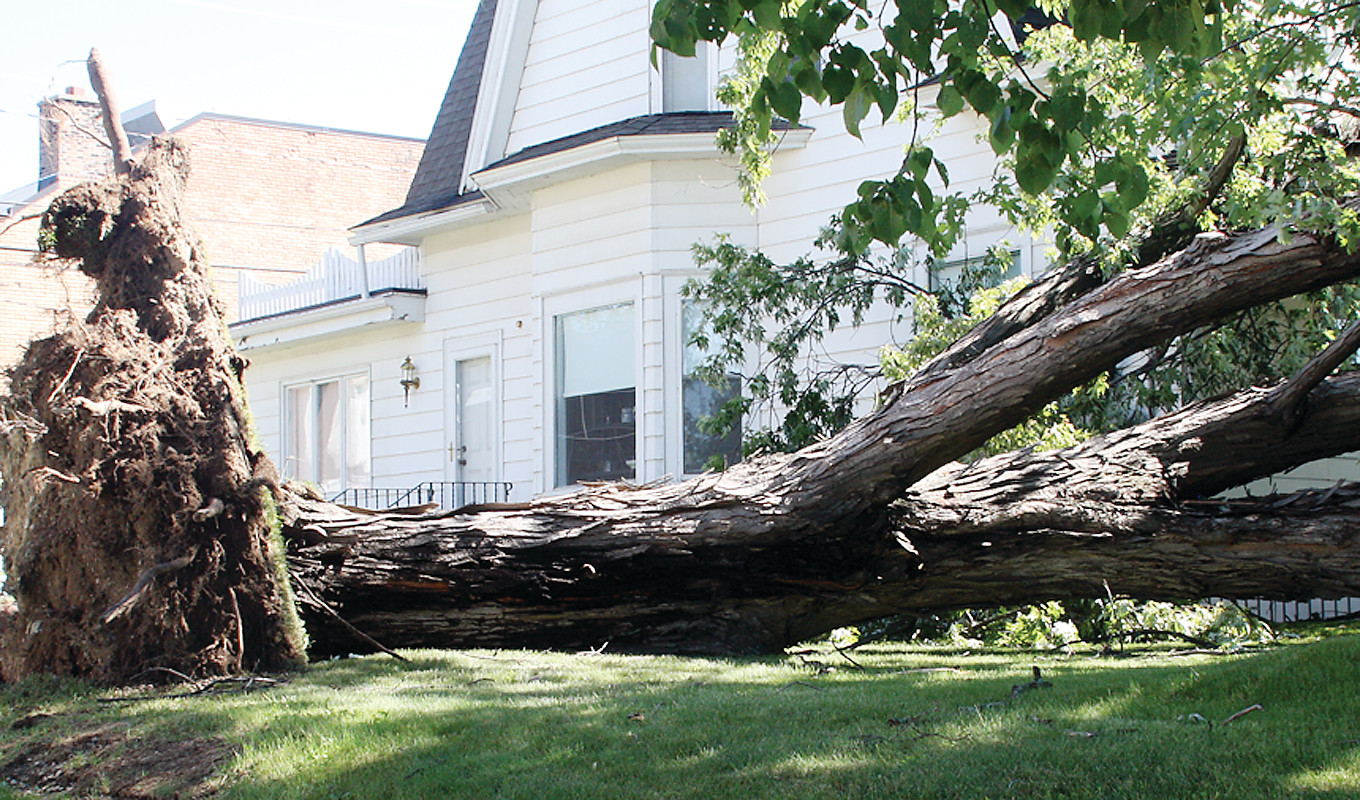
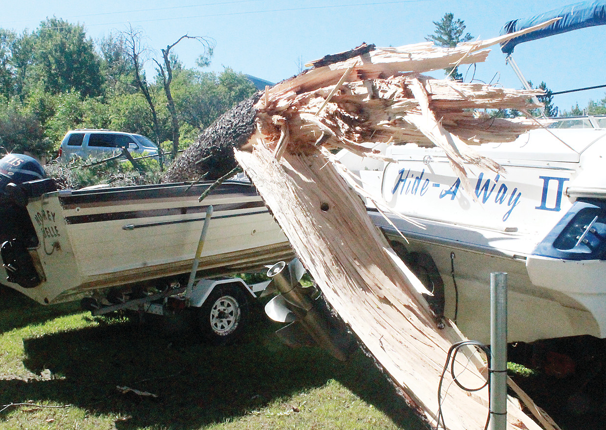


REGIONAL—Hurricane force winds pushed by one of the most powerful storms to hit northeastern Minnesota since the 1999 derecho, blasted through the region early Thursday morning, July 21, flattening trees, damaging buildings, knocking out power for tens of thousands of residents, and, most tragically, killing two campers just across the border in Quetico Provincial Park.
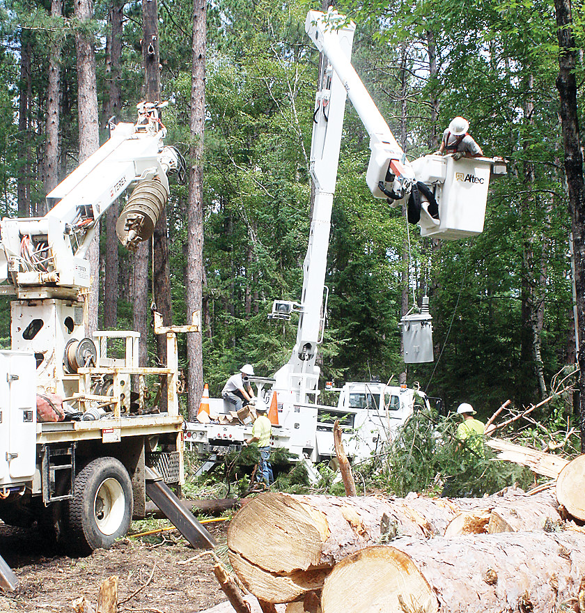
The storm left the majority of Lake Country Power’s 42,000 customers without electrical service, and many remained without power for days. As of Wednesday, nearly a week after the storm, about 1,000 customers were still without power.
“It is tedious work at this point,” said Todd Johnson, Lake Country Power’s director of operations. “But we continue working in the most difficult terrain and hardest hit areas.”
Most of the remaining outages in northern St. Louis County were focused in the rural lake communities around Ely, particularly around Burntside Lake and up the Cloquet Line, where the blowdown was extensive in some areas.
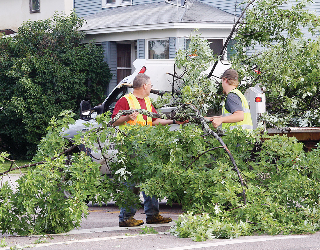
In the city of Ely, the storm downed or severely damaged hundreds of trees, according to City Clerk-Treasurer Harold Langowski. “We had public works crews that went out at 4 a.m. and starting clearing trees from the roads. It was probably about 11 o’clock that morning that they had the main routes passable.” Nearly a week later, Langowski said final clean-up will still take a few more days.
The city’s public utilities also took a hit, as falling trees took down power lines in nearly 20 locations, with some utility poles damaged as well, particularly near Burntside Lake, where the city maintains its water pumping station. Falling trees also ripped out individual service lines from about two dozen residences.
Minnesota Power’s main electrical feed was also severed at the city’s substation, which knocked out power to the entire city. The damage was repaired and power restored to all but a handful of city residents as of 11 a.m. on Thursday.
In the meantime, Langowski said he’s trying to tally the cost to the city of the clean-up effort, noting that St. Louis County is preparing a request for a state disaster designation.
The extraordinary storm easily met the meteorological definition of a derecho, said State Climatologist Kenny Blumenfeld. Derecho is the name for an extremely powerful and long lasting storm event that includes pockets of hurricane force winds and creates extensive damage across 250 miles or more. “In this particular case, no matter how you define it, this one definitely fits the definition,” said Blumenfeld. The storm blew up in eastern North Dakota late Wednesday evening, creating a path of destruction all the way into northeastern Wisconsin.
Wind speeds reach hurricane force at 74 miles per hour, and Blumenfeld said official weather instruments clocked wind gusts of that speed or higher, with a weather service recorder in Hallock, in northwestern Minnesota, hitting 83 miles per hour. He said the nature of the damage also points to pockets where gusts reached 100 miles per hour or more.
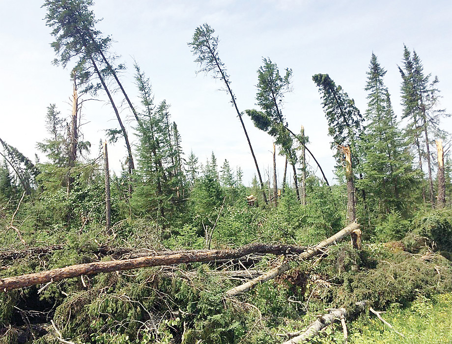
Damage to trees was extensive and some areas near Ely and elsewhere in the region had blowdown reminiscent to that seen in the aftermath of the 1999 storm, which flattened 350,000 acres of trees in the Boundary Waters Canoe Area Wilderness. But whereas that storm focused its fury on the border country, the most recent storm wreaked havoc across a broad swath of northern and east central Minnesota. Indeed, Duluth was among the areas hardest hit, with much of the city without power for days. St. Louis County reported a wind gust atop their Government Services Center in Duluth in excess of 100 miles per hour, while the wind gauge atop the aerial lift bridge, at the entrance to the city’s harbor, clocked winds at 80 miles per hour. The storm caused extensive damage to infrastructure in the Duluth area, with some neighborhoods without power for several days. The storm also affected broadcast reception from Duluth television and radio stations after damage to the antenna farm there took some time to repair.
Downed trees affected Boundary Waters rescue
When the call came in about 4:30 a.m. on Thursday about injured campers on Basswood Lake, members of the St. Louis County Rescue Squad and the Morse-Fall Lake Fire Department responded. But just getting to Latourell’s Moose Lake facility took extra time as the responders had to cut through the numerous trees that were down across the Fernberg Road.
Rescue squad lieutenant Kurt Erickson reported needing a backhoe to clear his side road just to access the Echo Trail as he sought to respond to the Basswood call. “I stopped counting the downed trees at twenty,” he said.
It was a Boy Scout group, affiliated with the Northern Tier camp near Ely, that had run into tragedy as a large red pine crushed a tent with three people inside. A young scout and a mother who was chaperoning on the trip both died. A third person, another scout in the tent, was pinned and badly traumatized by the incident, but appeared to have only minor physical injuries. The Morse-Fall Lake responders focused on freeing the one survivor, assisting Canadian officials since the incident took place just across the border in Quetico Provincial Park.
Once the surviving camper was freed, the crews temporarily halted the body recovery until Ontario Provincial Police could make it to the scene.
The American rescuers did a reconnaissance on the U.S. side of Basswood, finding several near misses but no other significant injuries, other than one camper with a broken leg, who had been evacuated earlier in the morning.
Derechos not unusual in the state
While some states, like Kansas and Oklahoma, are part of what’s known as “Tornado Alley,” northern Minnesota is within its own high frequency corridor, says Blumenfeld, for derechos. “Getting one a year, on average, is not that unusual, but generally not in the same place,” he said.
While derechos aren’t that uncommon in Minnesota, Blumenfeld said they often aren’t immediately recognized or reported as such. “With a tornado, someone has to make a survey of the damage and a determination is often made quickly,” he said. “With derechos, it’s a little different. The National Weather Service will survey the damage, but only in its local jurisdiction.” But since part of the definition of a derecho is that it is long-lasting, they often pass through multiple jurisdictions, and it can take time for the weather service to put the pieces together and make a final determination. That usually comes weeks after the event has passed and news coverage has moved on to other stories.
But this event is likely to pass the “memory test,” said Blumenfeld, much like the 1999 storm.
If there was a silver lining to the event, Blumenfeld said it came in the form of relief from a severe heat outbreak in the southern half of the state. “The storm was so powerful that it really knocked back the heat wave,” he said, noting that temperatures that had hung in the low 80s overnight in southern Minnesota dropped 10-15 degrees almost immediately as the derecho brought the jet stream, and its cooler air, down to the surface. The cooler air lingered the next day, said Blumenfeld, taming what forecasters had initially predicted would be a heat emergency over much of southern Minnesota.


